Recommended Rides.
On this page we welcome
descriptions, tips and photos of rides that you have done and
enjoyed. These rides do not necessarily have to be off road, as
long as they are safe and enjoyable. It would be great if you
could let readers know how much is off road, what the parking is
like, and how busy any road sections are.
Please e-mail us
with the details and any photo's if possible.
Rides@Carmsriders.co.uk
Keepers Lodge 09/07
KEEPERS
LODGE RIDE
1. From Keepers Lodge
car park turn left out of the venue and onto the road.
2. Follow the road up the hill past the forestry track and car
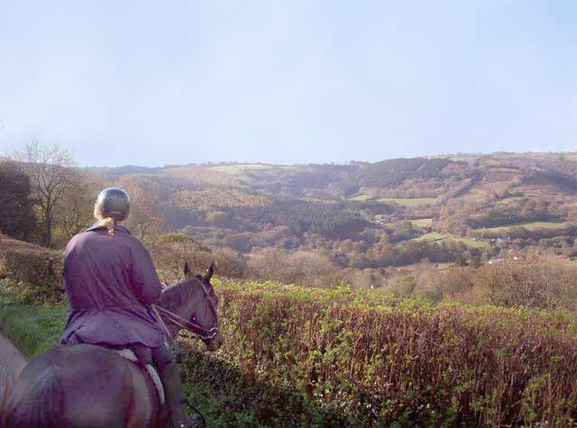
park on the right and admire the view on the left! (Sorry about
the road but only way to the bridleway) Turn right onto the
bridleway (orange mobile signal here -approx 1km from the
venue) Follow this bridleway for approx 1km through a green
metal gate. It is a little muddy in places.
3. It meets a track on the right, turn right here. Follow the
track paying attention to the going as may be soft if the
weather has been wet. (There are a few small logs) The track
will have a steep drop on the left before you meet the road.
Please be sensible and keep to the right.
4. This track eventually comes out onto the road. Turn left.
(this is a 2 way section) Follow the road for approx 1km and
take the turning on the right to Llidiad Nenog ( the tarmac can
be slippery)-orange mobile signal on this road
5. At the hairpin bend at the top, turn right to Clyn Wallis.
Take the right track at the fork.
6. Immediately after the fork there is a track to the
left. Follow this. (this junction is the end of the 2 way
section)
7. At the end where it meets a wider track, turn left. Keep left
to avoid the gulley.
8. You come to a very awkward gate. You will have to dismount.
Please close the gate
9. Follow the track to another gate. Please close the gate.
When you reach the road turn right.
10. Past the church and take the next track on the right
alongside the house with a serious fence. (large dogs in the
garden) orange mobile signal here
11. Follow this track
and the bridleway markers. It bears off to the right and then
left again finally following a downward slope and across a small
stream (it is muddy by the bridleway post after the stream-walk
through it) to a gate and a river.
12.. Cross the river and follow the track. This track is rocky
for the first section but improves and eventually comes out at a
small bridle gate. Turn right and through the cattle grid gate.
Please close the gate (signed Banc Farm) orange mobile
signal here
13. Follow the tarmac
road through another cattle-grid gate Look for (and avoid) a
drain that your horse could put his foot in on the approach
Please close the gate. You can ride on the grass but don’t scare
any sheep and keep close to the edge. Nice place for a canter.
14. Through another
cattle grid gate and follow the road a short distance to a gate
on your left into a large field.- orange mobile signal here
15. Go through the gate Please close the gate and tie it
and follow the fence line to your right. (if there are cattle in
the field please walk past them) Past the tree on the right and
to the gate at the bottom. The best route has been marked with
tape. There is standing water and you may get your feet wet at
the gate if your horse doesn’t do gates.
16. Go through the gate. Please close the gate.
At the junction (cross roads) go straight ahead.
17. keep going straight ahead at the next 3 junctions
18. See a waymarker post ( orange mobile signal here) at
the third, pass it on your left heading down hill to
Rhandir-gini and a building on your left.
19. Through 3 very awkward gates. Please close them. (Orange
mobile signal intermittent) There may be cattle in this
section so please walk if you see them. There is an open field
please keep to the edge. Canter only if no cattle present.
20. There is another gate and you continue down hill on a track
eventually with water damage (gulleys) Please take care. You
might be better walking in the gulley in places.
21. You come out onto a road but turn immediately right at the
wooden way-marker post. Vodaphone signal here
22. Follow this track
to the river. Cross the river.
Follow the track up hill to the forestry road. (The surface is
rocky in places.)
23. Turn left onto the forestry road. After about 100 meters
take the track on the right at the bend by the waymarker post.
(its actually straight ahead)
24. You come to another waymarker post where you turn left.
Through a muddy puddle and onto a grassy path. At the end you
see a forked forestry road on your left. Take the lower road.
25. Immediately after there is a gap in the vegetation on the
right going down hill. Take this path. At the end of this track
turn right (there is a waymarker on your left at the bottom) The
mud here is deep, about fetlock deep so walk.
26. Follow the
forestry road to the 2way point. (waymarker post)
27. Follow the forestry track back the way you came and out onto
the tarmac road. (orange mobile phone signal here)
28. Turn left and go down the hill to the junction and turn left
(go wide as the tarmac is slippery)
29. Follow the road for about 1km and take the turning on the
right at Brynmadog( by Silver dustbin). Wooden waymarker post on
the right.
30.follow the stone road to the gate on the left. Through the
gate Please close the gate
31. Across the river and follow the path through the bridle
gates. You can leave these open. Be careful in the muddy bits.
Not suitable for canter unless the weather has been very dry.
32. At the last gate into the yard, please be courteous.
Through the wooden gate and onto the track. Follow the track to
the road. You can see the venue ahead of you.
Keepers Lodge Circuit 25 km
(Ridden Feb 07) From the
car park head into the forestry past the wooden shed on the
right and through 2 small gates. Follow this forestry track over
the bridge across the river and turn right. Follow this track,
which is surfaced with shale and stony in places from water
damage. At the junction take the right track heading upwards.
Don’t turn left. This track continues to go upwards until you
come to a heavy duty green metal forestry gate.
At the tarmac road turn
right to the cattle grid, through the gate and turn immediately
left onto the open mountain (be aware of any ponies –keep away
from them). Follow the fence line to your left, about 20metres
parallel to it to a tarmac road.
Turn left onto the
tarmac road and through a cattle grid gate (openable on
horseback) Continue down the road and past the black shed on
your left to a bend in the road. Take the track up the grassy
hill from this bend (not the stony road) This is soft going and
follows the fence line to the right for a short distance before
leaving the fence and continuing over the mountain. This path
goes down to the river bearing slightly right. Cross the river
and continue upwards. This is stony at first but gets better.
This comes out onto a gravel road.
Go straight across
following the fence to your right. When you reach the gate to
your right there is a line of telegraph poles to your left. Turn
left here and follow them, counting as you go. (be aware of
ponies and stay away from them) Be mindful of wet patches and
keep to sheep tracks or dry ground. At the 6th pole
turn 90 degrees to your left keeping to the top of the mountain.
There is a valley with a river in it to your right and you will
see 2 farms to your right below you and on the other side. Keep
to the top and follow the valley until you come to a stony cart
type track ahead of you. You should continue following the
valley to your right until you come down to a stream. There is a
small house situated on the edge of the moorland and the
farmland in line with the 2 farms previously mentioned. Cross
the river/stream and you pass to the left of it. There is an
ornate stone bridge on your right (do not cross it). Follow the
track, which is stony in places but also grassy too. At the end
turn right, then turn left onto a tarmac road heading downwards.
This is Very Slippery so
please be very careful. Keep to the grassy verge where possible.
Cross the river at the bottom and up the hill, still following
the tarmac road. At the T junction go straight across and follow
the fence line to your right. There is a small indentation in
the ground ahead of you like an ancient ditch. This “is” the
bridleway. Leave the fence at the corner post and continue in
the same direction that you were, until you come to a stony
track. You can see the pine forest on the hill in the distance
with the road going through it. Head towards the telegraph
poles. Go straight across at the stony track until you come to a
tarmac road.
Bear right onto the
tarmac road and through the cattle grid gate (not openable on
horseback).
Follow the road past
Cross Inn Farm and take the next road on the left after the
phone box.
This is Banc Farm drive.
Follow this road until you come to a cattle grid. Just before it
is a small gate on the right. Go through this gate (openable on
horse back) and follow the track in front of you slightly down
hill. This becomes a path. It does look wet but it has a solid
bottom. Follow the track downwards, eventually meeting a hairpin
bend ahead of you. Keep left. Across the river and to the left
through a wooden gate (openable on horse back but currently a
bit wet but solid bottom). Follow this track bears right.
Eventually goes up hill and across a muddy patch where forestry
vehicles have churned it up. (Pick your way carefully, keeping
to the edges as it can be deep in places) The track then goes
down to another stream and upwards through some amazing
woodland. It meets another track to the left and right , bear
slightly right. There is a bridleway marker on a post on the
left at this track pointing the way you have been. Keep heading
upwards and the track eventually comes out onto a tarmac road.
Turn left, (big dogs but
well fenced) past the blue church to the next bend where there
is a driveway down to your left (hair pin). Turn left here and
go through the gate at Pant y Betws and follow the old county
road. Past an old farm building and through another gate (not
openable on horseback) continue downhill. This road has an old
fence on the right. Just after a track on your left there is a
track on your right (staggered junction) about 1km from the
gate. It will have gullies in it caused by water. The route
will continue ahead of you but take the right turn heading
downwards. The track bends round and becomes a narrow
earth/gravel track bordered with prickly bushes and small
trees. It comes out onto a forestry junction. Go straight ahead
(not left). The track is a wide forestry road and you pass
fields on the left with sheep and horses in just before the
house (Clyn Wallis). This then comes to a tarmac road on a
hairpin bend.
Bear left downwards and
turn left at the end keeping on the road. Go across the bridge
and about 1km further on there is a turning on the right onto a
stony driveway towards the property Brynmadog and Hendre Fadog.
Down the track a few hundred yards and take the route through
the metal gate on the left where the track turns to the right.
This gate swings away from you. Follow the bridleway across a
stream passing 2 narrow gates (openable on horseback) to a metal
gate (not openable on horseback) where the bridleway meets the
cottage yard. Through their yard and another gate (openable on
horseback). Follow the lane to the road and Keepers Lodge Car
Park is ahead of you across the road.
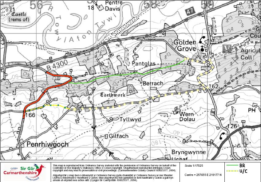
Golden Grove / Gelli Aur
New Bridleway.
Please have a try and let us know what
it's like. Pictures would be nice if possible.
Many
thanks to CCC for their help.
We are
waiting for the results for a request for
some
"SLOW Horses" signs on the part marked in red,
which
we believe to be quite steep and twisty.
Llyn Llech Owen
(last ridden 01/08/07)
Lovely new rides although the paths are just
hard stone ( plus shared access ) so no fast work.
From cross hands roundabout - take the road to
Llandeilo.
At six ways, (pelican crossing) take the
second left. Park is about 1 mile on the right. ( Top of the
hill. )
Not sure about parking, but we park on the
road leading into the park. About 100 yards up there is an
entrance with a log barrier that leads to the bridle ways. There is a new car park, but there was nobody about top ask
about horse boxes.
This is a very pretty ride with good views
etc. The paths are newly laid stone so should be good in any
weather. There is not a large selection of routes or a vast
area, but good if you are local or the ground is wet. No where
for cantering yet. Work is ongoing, so hopefully they will put a
softer top surface on.
Watch out for walkers etc.
Thee is a coffee shop there, but not sure
about opening hours.
Good if you have people that want to take a
walk or cycle while you ride. Visitors centre for walkers.
Keepers
Lodge, Brechfa
8.5km
route Last ridden on 4/11/2006
From Keepers lodge turn left out of the car
park and head north east (take a right off the road immediately
where bridleway sign is (although don’t follow its direction
down the hard forest road) follow the track through a new wooden
gate with horse catch past the cottage shown as Llain on the OS
Explorer map. Through the cottage yard and on the bridleway
through an NEW METAL GATE. Follow the track through WOODEN GATES
(horse friendly). The track has now been resurfaced but
will take time to settle completely.
Thank you to
C.C.C.
Leisure and Recreation Division and the
Community Council who have improved this route for us at the
request of Carmarthenshire Riders.
Watch this space for more improved routes and
the progress with waymarking of routes.
Over a stream to a new metal gate which is
difficult to open and close on horseback as gate swings open.
Turn right down a stony track to the road turn left. Follow the
road until you reach a stone bridge over the river. Before
crossing the bridge take the path to your left. Follow this
until it meets a wider track running down hill. Turn right.
This is a bridleway. It is a bit muddy in places and also
slippery in the wet but generally has a stony bottom. Through a
small gate next to a rhododendron tree. (needs cutting back).
Past the dumped plumbing waste on the right over a stream and
out onto a road. This road meets another at the old post
office. Turn right. Follow the road and take the left fork up
hill. At the hairpin bend take the track off the road towards
“Clyn Wallis”. This is a byway. Take the lower track to the
right and off that track almost immediately on the left is a
small path. You will find some old marker posts along it
occasionally. (this needs some cutting back but is passable).
Turn left at the junction (cross roads) This is an old county
road. Follow the road to a gate faulty catch and tied with
string. To another gate. Openable from horse back but not
closeable as horse needs to put his head in a bush! When you
meet the road turn left. Lovely view to the right in good
weather. Follow the road round the hairpin bend you turned off
earlier and back down the hill. Turn left at the road and
follow the road over the stone bridge and back to Brynmadog.
Turn right onto the stony track and back through the gate that
swings. Through boggy bit and broken gate. Back through old
wooden gate to Cottage and out onto the road. Keepers car park
is in front of you.
BEACH RIDES
We
have now heard from Carmarthenshire council regarding beach
access, here is their response.
Pembrey Beach
Highly recommended even with the £5 charge. vast beach and great
forest tracks which are sandy in the main and fallen trees to
pop over etc. Do keep an eye open for walkers and cyclists. (P.Y.)
East of Cefn Sidan - newly installed 'horses for the beach'
signs at beach access point F (at the end of the byway - reached
from the free car park on the left before Pembrey Park.)
The signs will indicate that when approaching the beach from the
byway at F, horses will be permitted to turn left towards Burry
Port to the South East but will NOT be allowed to turn
right onto the Blue Flag Award winning section of Beach (between
F and A) due to conflict with other users, bathing quality etc.
West of
Cefn Sidan Beach and Forestry - access only via Equestrian Centre inside Park
who has access agreement with Forestry Commission and
Carmarthenshire County Council to access certain areas of FC
land and beach.
For advance bookings telephone: The Cowin Riding Centre 01554 832160.
Charge is about £5 per horse. Parking is available at the Riding
Centre. ( Go through main entrance to Pembrey Park and it's the
first lane on the right. ) Tell the gate operator that your box
is booked into the riding centre and they should let you in for
free.
From the Council point of view we would advise that all Riders
would require public liability cover to cover their time spent
on land in CCC ownership ( which includes the beach between mean
high and mean low
water)
For Marros, Pendine & Laugharne - no restrictions except when
MOD section of Pendine beach is operational
With regards Ferryside and Llansteffan - both these are Crown
owned beaches with limited access across County Council land. We
consider that these two beaches do not offer sufficient access
opportunities for Equestrian use to include them in your
website.
Please also take a look at
Carms Riders Message Board for riders comments.
|